About IGNrando' – France hiking maps
IGNrando’ is a collaborative platform for sharing routes and points of interest (POIs) related to outdoor activities in France. RICH DATA OFFER • Tens of thousands of routes and POIs all accross Metropolita
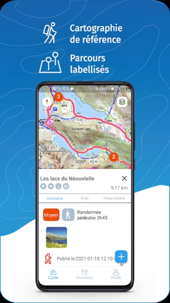
IGNrando’ is a collaborative platform for sharing routes and points of interest (POIs) related to outdoor activities in France.
RICH DATA OFFER
• Tens of thousands of routes and POIs all accross Metropolitan and Overseas France
• Choose the activity, difficulty level and route length to find routes around you or near any other place
• Download or mark as favorite the desired routes or POIs
MAPS & LAYERS IN FREE ACCESS (with internet connection)
• Plan IGN: most updated map, suitable for all activities
• Aerial photos (IGN)
• OpenStreetMap Outdoors: world map with hiking routes & contour lines
• OpenCycleMap: world map with cycling routes & contour lines
∙ Spain IGN map
∙ Swisstopo map
∙ Emergency calls (112) mobile network coverage map for France
∙ OpenSnowMap
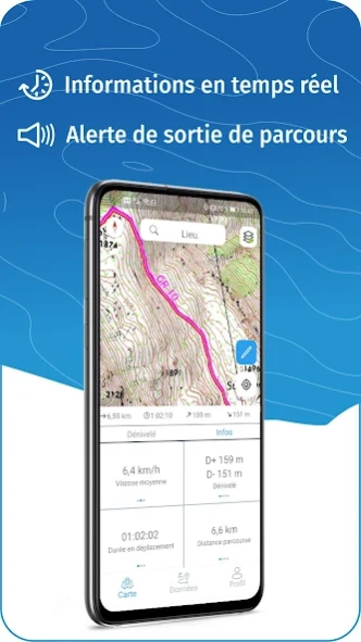
GPS GUIDING ALONG ROUTES
• See your progression on the altitude graph
• Get alerted if you exit the route
• Get notified of upcoming POIs or route info points (available soon)
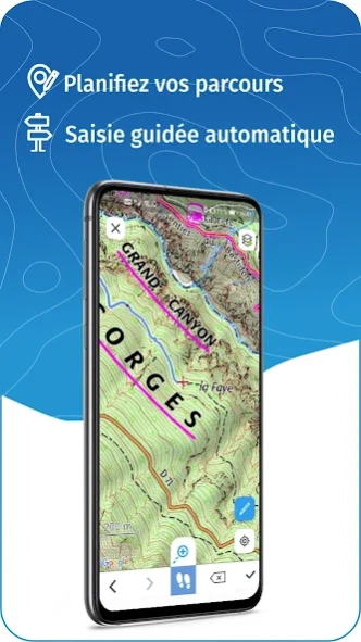
GPS TRACKING AND DATA CREATION
• Record your own routes with GPS tracking
• Quickly create routes on-device with the automatic routing tool that follows roads and paths (online only, with subscription)
• Create Points of interest
• Send your routes to
ignrando.fr for backup or to publish them
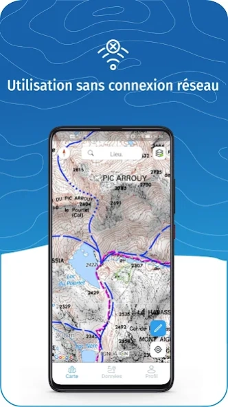
OFFLINE USE
• The GPS keeps working even without internet: see your position on the map, use GPS guiding and record routes
• Downloaded routes: descriptions, photos and guiding remain accessible
• Downloaded maps (with subscription)
Useful tip: Enabling Airplane Mode or disabling Mobile Data improves battery life, without affecting the Location Services (GPS)
IGN MAPS SUBSCRIPTION
• Create routes with pedestrian and vehicle routing
• View & download the following maps & layers:
∙ All free version maps
∙ IGN maps (various scales)
∙ IGN 1:25k topo maps (Top 25): the famous French topographical maps available at all zoom levels
∙ 1950 IGN maps
∙ Military maps (1820-1866)
∙ ICAO aeronautical charts
∙ France mobile network operators coverage maps
∙ Cadastral parcels layer
∙ DFCI grid (forest fire protection grid)
• Drones flight restriction areas
∙ Roads & paths layer (only available with Aerial photos)
Play Store subscription
• Linked to Google account
• Automatic renewal unless cancelled at least 24 hours before the end of the current period
• Auto-renewal may be turned off after purchase
IGNrando' store subscription
• Linked to IGNrando' account
• No automatic renewal
• Can be used on 3 devices at the same time
Use an SD card to store your data
Free space on your device.
——————————————————————
Got ideas to improve the IGNrando' app
Write us on:
[email protected]
Previous Versions
Here you can find the changelog of IGNrando' – France hiking maps since it was posted on our website on 2019-07-25 14:52:26.
The latest version is 1.97.02 and it was updated on 2024-04-19 17:45:26. See below the changes in each version.
IGNrando' – France hiking maps version 1.97.02
Updated At: 2024-04-17
Changes: • Added "Winter routes" overlay
• Other recent changes:
- Added "Emergency calls (112)" and "My provider’s network" overlays
- Added zones forbidden for aerial photography (ZICAD) in the “Drone Restriction” overlay
- Changing the position of a point of interest by moving it on the map
- Added display of paper IGN maps in route description
IGNrando' – France hiking maps version 1.96.1
Updated At: 2024-03-20
Changes: • In-app updates: get notified when a new version is available
• Other recent changes:
- Possibility to modify the duration of routes
- Added suggested communities
- Better use of location sources
- Improved support for opening of GPX, KML, KMZ & ZIP files with app
- Track editor
IGNrando' – France hiking maps version 1.95
Updated At: 2023-08-21
Changes: • Improved support for opening of GPX, KML, KMZ & ZIP files with app
• Improved handling of location permission problems
• Other recent changes:
- Corrections for location problems
- Choice of location source in settings
- Improvements to edit track feature
IGNrando' – France hiking maps version 1.94
Updated At: 2023-06-06
Changes: • Corrections for location problems
• Choice of location source in settings
• Improvements to edit track feature
IGNrando' – France hiking maps version 1.93
Updated At: 2023-04-25
Changes: • Reenables display of IGN maps for devices using Android 5 and 6
• Other recent changes:
- Edit the track of routes created or imported in the app
- Integrated help in "Profile"
IGNrando' – France hiking maps version 1.90
Updated At: 2023-04-08
Changes: • Bug corrections on route recording
• Other recent changes:
- Edit the track of routes created or imported in the app
- Integrated help in "Profile"
IGNrando' – France hiking maps version 1.76
Updated At: 2022-05-06
Changes: . Location sharing: share your location with your friends and see the friends who shared their location with you on the map
IGNrando' – France hiking maps version 1.74
Updated At: 2022-03-29
Changes: . Improved KML/KMZ importing capability
. Better Android 12 compatibility
IGNrando' – France hiking maps version 1.71
Updated At: 2022-02-11
Changes: . Option to save maps to external storage in Settings
. Share Routes & Points of interest as links
. Open Routes & Points of interest links in the app when installed
. Connection with Outdoorvision program, participation can be deactivated in Settings
IGNrando' – France hiking maps version 1.67
Updated At: 2021-12-09
Changes: . Adds "Communities": find your followed communities in "Data" and access communities from routes and points of interest descriptions
. Adds "Modify display settings" section in "App settings"
Disclaimer
Official Google Play Link
We do not host IGNrando' – France hiking maps on our servers. We did not scan it for viruses, adware, spyware or other type of malware. This app is hosted by Google and passed their terms and conditions to be listed there. We recommend caution when installing it.
The Google Play link for IGNrando' – France hiking maps is provided to you by apps112.com without any warranties, representations or guarantees of any kind, so access it at your own risk.
If you have questions regarding this particular app contact the publisher directly. For questions about the functionalities of apps112.com contact us.